 |
Photo
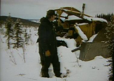
B1 – On July 14, 1984 Joe Vogler’s D-8 Caterpillar tractor was
stopped on the Bielenberg RS 2477 trail between Circle and Woodchopper
by National Park Service Rangers holding a temporary restraining order.
These first four photos were taken the following winter by KUAC-TV.
[KUAC279] |
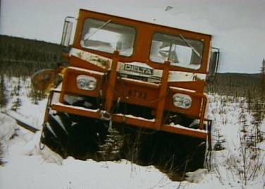 |
Photo B2 - Joe Vogler’s all terrain Delta-3
transport vehicle was also stopped on the Bielenberg trail with the D-8
Cat in the Yukon – Charley Rivers National Preserve near Webber Creek.
[KUAC280] |
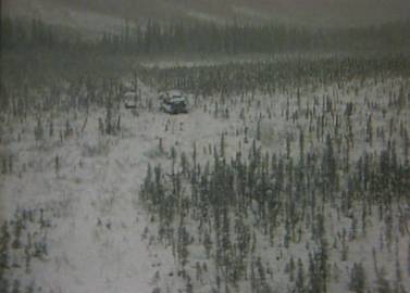 |
Photo
B3 - Joe Vogler’s D-8 Cat and the Delta-3 transport at location
stopped. Note the stunted
black “swamp” spruce in this poorly drained “muck” and tundra
permafrost terrain [type Fs, described below].
Unlike the McCarthy – Green Butte Road, it would be impossible
to traverse the Bielenberg trail by truck or other wheeled vehicle in
the summer. [KUAC278] |
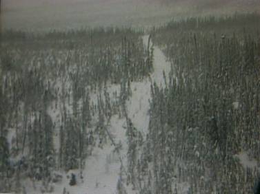 |
Photo
B4 – The Bielenberg trail here traverses some of the most sensitive
terrain in the state of Alaska to damage from thaw and hydraulic erosion
of ice-rich soil. Much
of Vogler’s route traversed hills and ridges covered with thick,
perennially frozen organic silt. This terrain was found along the
Alyeska Pipeline corridor to contain shallow massive ice as thick as 50
ft. [KUAC281a] |
 |
Photo
B5 – Thick
deposits of ice-rich, retransported silt [Fs], were termed ‘muck’ by
the
early miners because of its fetid smell.
This terrain is typical of what underlies the Vogler route and it
forms a unique landform in interior Alaska with inherent engineering
problems and land-use constraints that create impacts on development
that far outweigh the actual percentage of the landscape it covers. [Fs01] |
|
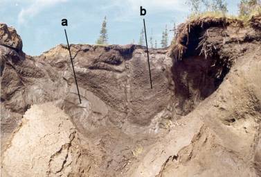
Massive
ground ice at “a” and the soil+ice body at “b” are subject to
rapid thermal and hydraulic erosion if the surface mat of tundra mosses
and tussocks is mechanically disturbed enough to expose the underground
ice to thaw.
|
|
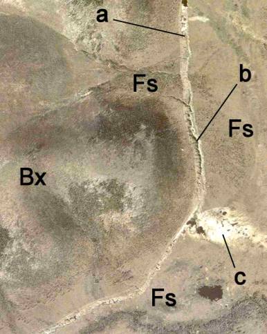 |
Photo B-6 – Example of extensive terrain damage from thawing bulldozer trail (a) in thick deposits of frozen, retransported organic silt [Fs] in valley bottoms containing massive ground ice. Thermokarst features (thaw ponds) indicate the presence of ice-rich permafrost beneath lower slopes and valley bottoms. Dark-toned thaw ponds have formed in bulldozed trails that are vegetated by light-toned grasses and sedges. Note sheetflow drainage captured by the subsiding cat trail at (b) which has now eroded a canyon and redeposited the silt at (c). More stable upland terrain is weathered bedrock (Bx). Location: along Alaska Highway near Scotty Creek Flats. [cat-trail-erosion] |
|
There
was a potential for this type of damage to occur along the Vogler route
on the Bielenberg trail. It
was understandable for the National Park Service to have concerns in
this type of sensitive terrain. However, there is no chance for anything remotely like this level of terrain impact to occur along the McCarthy – Green Butte Road. The terrain there is thaw-stable gravel and dense till. A very safe and resistant terrain for any type of tracked vehicular travel, especially over an existing road surface. |
|